For those wishing to use GPS, the street address is 6517 Highland Haven Road NE, Copper Hill, VA 24079 (some map data may list the street name as Highland Haven Run).
The GPS co-ordinates are:
- lattitude: 37.050989
- longitude: -80.192666
Caution: U.S. 221 between Roanoke and Adney Gap and the portion of State Route 8 south of the Blue Ridge Parkway are not recommended for inexperienced RV drivers. Both have many sharp curves and steep grades (about 10%).
Some GPS systems can give unreliable directions leading you to very RV-unfriendly roads, so we are including driving directions from the major highways serving the area below.
Click below for a larger interactive map!
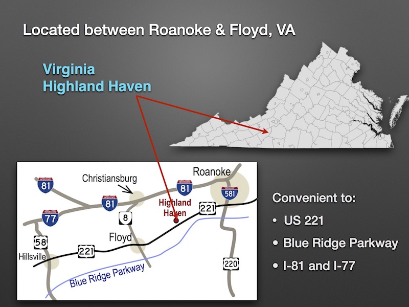
The Blue Ridge Parkway is now open between US 220 (Roanoke) and Adney Gap (north of VHH)!
From the South on I-77: Exit 14, right onto U.S. 58 East for 2.7 miles, keep left to Hillsville and onto U.S. 221 North for 41.9 miles (passing through Floyd), left onto Daniels Run Road NE (SR 610). From Daniels Run Road, follow directions at bottom of the page and look for signs to the park.
From the Southwest on I-81: Exit 114, right onto State Route 8 South for 19.4 miles, left in Floyd onto U.S. 221 North for 14.2 miles, left onto Daniels Run Road NE (SR 610). From Daniels Run Road, follow directions at bottom of the page and look for signs to the park.
From the South on U.S. 220: Approaching Roanoke turn onto the Blue Ridge Parkway south for 14.6 miles to Milepost 136, exit right at Adney Gap and then left onto U.S. 221 South (towards Floyd) at Milepost 136 (Adney Gap) for 6.9 miles, right onto Daniels Run Road NE (SR 610). From Daniels Run Road, follow directions at bottom of the page and look for signs to the park.
From the Northeast on I-81: Exit 143, left to I-581 (in Roanoke) which becomes U.S. 220 South. Exit onto 419 West (Electric Rd - right turn at the bottom of the exit ramp) and then left onto U.S. 221 South (towards Floyd) for 20 miles. Turn right onto Daniels Run Road NE (SR 610). From Daniels Run Road, follow directions at bottom of the page and look for signs to the park.
From the East on U.S. 460: Turn onto I-581 South at Roanoke, exit onto 419 West (Electric Rd -right turn at the bottom of the exit ramp), and then left onto U.S. 221 South (towards Floyd) for 20 miles. Turn right onto Daniels Run Road NE (SR 610). From Daniels Run Road, follow directions at bottom of the page and look for signs to the park.
From the West on U.S. 460: After passing Blacksburg exits, turn right at Exit 3 onto U.S Business 460 East to downtown Christiansburg, right onto Depot Street NW for 0.7 miles, right onto State Route 8 South for 20.2 miles, left in Floyd onto U.S. 221 North for 14.4 miles, left onto Daniels Run Road NE (SR 610). From Daniels Run Road, follow directions at bottom of the page and look for signs to the park.
From the South on the Blue Ridge Parkway: Near Milepost 165 exit onto State Route 8 North (towards Floyd) for 6.0 miles, right in Floyd onto U.S. 221 North for 14.4 miles, left onto Daniels Run Road NE (SR 610). From Daniels Run Road, follow directions at bottom of the page and look for signs to the park.
From the North on the Blue Ridge Parkway: At Milepost 136 exit right at Adney Gap and then left onto U.S. 221 South (towards Floyd) for 6.9 miles, right onto Daniels Run Road NE (SR 610). From Daniels Run Road, follow directions at bottom of the page and look for signs to the park.
From Daniels Run Road to the campground:
After 1.3 miles on Daniels Run Road (SR 610), right onto Conner Road (SR 649) for 0.3 miles, then left onto Highland Haven Road (SR 792) for 0.7 miles to the park entrance.